Home Home

CCAMLR

Commission for the Conservation of Antarctic Marine Living Resources

  • Home
  • Skip to Content
  • Log in

Search form

  • About CCAMLR
  • Conservation measures
  • Science
  • Fisheries
  • Compliance
  • Data
  • Meetings
  • Publications
  • Circulars
Krill close-up
Photo by James Clark
  • English
  • Français
  • Русский
  • Español
  • Home
  • Science
  • Marine Protected Areas (MPAs)
  • MPA planning domains

Science

  • Scientific Committee
    • Scientific Committee representatives
    • Working Group on Ecosystem Monitoring and Management (WG-EMM)
    • Working Group on Fish Stock Assessment (WG-FSA)
    • Working Group on Statistics, Assessments and Modelling (WG-SAM)
    • Working Group on Incidental Mortality Associated with Fishing (WG-IMAF)
    • Working Group on Acoustic Survey and Analysis Methods (WG-ASAM)
  • CCAMLR Scheme of International Scientific Observation (SISO)
    • Information for Technical Coordinators and Scientific Observers
    • National technical coordinators
    • CCAMLR tagging program
      • Equipment Ordering Information
    • Observer honour board
  • CCAMLR Ecosystem Monitoring Program (CEMP)
    • CEMP Sites
  • CCAMLR Marine Debris Program
  • CCAMLR Scientific Scholarship Scheme
    • Previous Scholarship Recipients
  • Otolith Library
  • Marine Protected Areas (MPAs)
    • CCAMLR MPA Information Repository (CMIR)
    • MPA planning domains
  • Vulnerable Marine Ecosystems (VMEs)
Print this page
Increase font size
Decrease font size

MPA planning domains

Map of MPA planning domains in the Southern Ocean

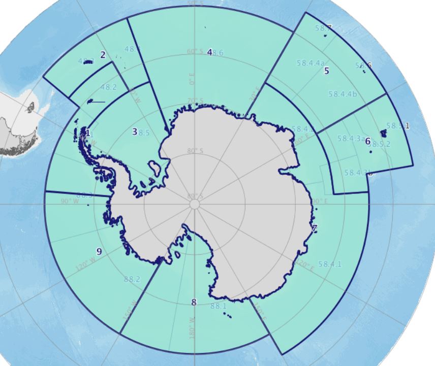
The CAMLR Convention Area is divided into nine MPA planning domains. These were defined during the 2011 CCAMLR workshop on marine protected areas (SC-CAMLR-XXX, Annex 6).

The division into these domains provides a mechanism by which to plan and report on the development of MPAs and as a means to organise future activities related to this effort. The planning domains are intended to reflect the scale and location of current and planned research efforts in order to be helpful as reporting and auditing units. The boundaries of the planning domains are not boundaries of proposed MPAs and are not intended to confine or restrict research or other work to develop MPAs.

  • Domain 1: Western Peninsula – South Scotia Arc
  • Domain 2: North Scotia Arc
  • Domain 3: Weddell Sea
  • Domain 4: Bouvet Maud
  • Domain 5: Crozet – del Cano
  • Domain 6: Kerguelen Plateau
  • Domain 7: Eastern Antarctica
  • Domain 8: Ross Sea
  • Domain 9: Amundsen – Bellingshausen

A map of the CAMLR Convention Area, onto which a layer of MPA planning domains can be applied, can be accessed via the Online GIS.

There has been extensive discussion of MPAs in the Scientific Committee and the Commission in recent years. These discussions are very difficult to summarise, however, all of the meeting reports of the Scientific Committee and the Commission are publicly available. The discussions in the Scientific Committee, focussed on the planning domains, are usually in section 5 of its report. For examples see the discussions from 2012 in the SC-CAMLR-XXXI Report (2.73 MB), paragraphs 5.21 to 5.30 and from 2014 in the SC-CAMLR-XXXIII Report (5.01 MB), paragraphs 5.11 to 5.45.

This page was last modified on 09 Aug 2018

Contact us

Email: ccamlr [at] ccamlr [dot] org
Telephone: +61 3 6210 1111
Fax: +61 3 6224 8744
Address: 181 Macquarie Street, Hobart, 7000, Tasmania, Australia
Postal address: PO Box 213, North Hobart 7002, Tasmania, Australia


Quick Links

  • Job vacancies
  • Schedule of Conservation Measures in Force 2021/22
  • Statistical Bulletin
  • CCAMLR Brochure

Recent and Upcoming Meetings

  • Log in
  • CCAMLR e-groups
  • Support
  • Copyright
  • Disclaimer and Privacy Policy
  • Sitemap
  • Intranet
  • Webmail
© Copyright - the Commission for the Conservation of Antarctic Marine Living Resources 2025, All rights reserved.  |  Top of page  |  Site by Eighty Options